How to Explore Any City in 3D on Your iPhone

Fly over skylines, tilt around landmarks and walk the streets — here's how to explore any city in stunning 3D right from your iPhone.
What 3D maps let you do
3D maps turn a flat map into a model of the real world. You can orbit the Eiffel Tower, glide over Manhattan, or scout a neighborhood before you visit.
The difference is depth. A flat map tells you a street exists; a 3D model tells you the street climbs, that the building on the corner is twelve floors of glass, and that the park you were counting on is on the far side of a motorway. That is the kind of detail that changes a plan.
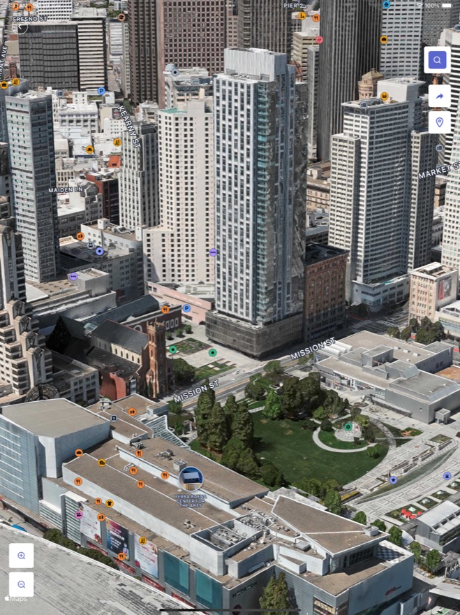
Explore in 3D, step by step
- Open MAPAS and search a city or landmark.
- Switch to 3D view to lift the map into a model.
- Drag with two fingers to tilt, and pinch to zoom in on buildings.
- Drop to street level to look around at eye height.
- Rotate with two fingers to swing the compass and see which side of a building catches the sun.
- Tap ahead in Street View to move down the street, one step at a time, the way you would walk it.
- Turn on GPS navigation to trace a real route between two points and check how long the walk actually takes.
Great cities to try first
- New York — the classic skyline from above.
- Paris — orbit the Eiffel Tower and Notre-Dame.
- Dubai — the tallest buildings on Earth in 3D.
- Tokyo — density that only makes sense when you tilt the camera.
- Istanbul — hills, water and two continents in one frame.
- Rio de Janeiro — mountains dropping straight into the city.
Plan a trip like a local
Use 3D to scout your hotel's street, find the nearest park, and get a feel for a neighborhood before you ever land.
Why explore a city in 3D before you go
Scouting a place in 3D before you travel saves real time. You can see how neighborhoods connect, find the best viewpoints, and get a feel for the scale of landmarks — so when you arrive, you already know your way around instead of burning your first morning getting lost. And when a trip isn't on the calendar, a 3D flyover is a genuine way to experience a city from your sofa.
It also settles the arguments that eat a holiday. Is the museum walkable from the station or is that twenty-five minutes uphill? Does the "sea view" room actually face the sea? Is the old town one square or six streets deep? Ten minutes in 3D answers all of it, and the answers are far more reliable than a photo chosen by whoever wrote the listing.
Tips for the best 3D experience
- Use two fingers to tilt the map and reveal the 3D buildings.
- Drop to street level for an eye-height look around any corner.
- Try famous landmarks first — they're the most detailed in 3D.
- Turn on satellite for realistic textures on buildings and terrain.
- Start high, then descend — read the layout from above before you commit to a street.
- Navigate by water and green space — rivers, harbors and parks are the easiest anchors to keep your bearings.
Where 3D has its limits
Worth knowing before you lean on it for a real plan. Detailed 3D building models are strongest in large cities; smaller towns often show terrain and satellite texture rather than modeled rooftops, which is still useful for reading a valley or a coastline. Street-level coverage has gaps too — narrow lanes, private roads and most interiors simply aren't photographed.
And the imagery is captured rather than live. A shopfront may have changed since the camera passed. When you want to see a place as it looks right now, switch to live cameras instead and watch a beach, a harbor or a mountain pass in real time.
Quick answers
Which cities look best in 3D?
Major cities with detailed models — New York, Paris, Tokyo and London are stunning. Coastal and hilly cities are the other treat, because tilting the camera shows elevation that a flat map hides completely.
Do I need internet?
Yes — 3D map data streams as you explore, so a connection keeps it smooth. If you're on a limited plan, do the long exploring sessions on Wi-Fi and save the on-the-ground navigation for mobile data.
Does it work on iPad?
Yes, and the bigger screen suits 3D well — tilting a whole skyline is easier when you can see the horizon. Plenty of people plan a route on an iPad at home and then follow the same route on their iPhone once they're there.
Can I plan an actual walking route with it?
That's one of the best uses for it. Walk the route in Street View first to see the crossings, stairs and gradients, then run it with GPS navigation so the turns are familiar before you take a single step.
Start exploring
MAPAS puts 3D maps, street view and live cameras in one free app — download it on the App Store and fly anywhere. No sign-up, no ticket, no waiting for someday.
Ready to start exploring?
Download MAPAS and turn these guides into real adventures.
Download on theApp Store